Notes by Todd Monge
It is a welcome relief to find a stretch of wilderness in Kenya, away from the hordes of tourists clamoring to view wildlife, charging across the plains in their safari vehicles. Ironically, Lake Magadi is only a three-hour drive from downtown Nairobi. But once you leave the environs of the bustling city behind, you enter a world of remote beauty, rarely visited by the tourist.
Lake Magadi is one of several soda lakes that grace Kenya's Rift Valley. It is a vast expanse of shallow, briny water and featureless salt flats. The lake is ravaged by the intense Kenyan sun; the shallow water and salty ground mirroring the heat, radiating it in stifling waves from the crusty surface of the earth. Wildebeest and zebra dot the landscape, their stripes seeming to ripple in the unstable air. A zebra brays and the sound carries across the vast emptiness, hollow and forlorn. A rugged escarpment rises from the shores of the desolate lake, and looking down, along the length of the shimmering water, the frail pink wings of flamingos beat the still air. The birds gather in huge flocks, rimming the shore with a rosy explosion of feathers.
Moving away from the lake you enter the bush and encounter the pastoral Maasai tending to their herds of cattle. They smile and wave, not jaded by legions of tourists as are their brethren in other parts of the country. Driving through the acacia brush you encounter their bomas, enclosed by thorns, and the Maasai come running, not to beg, only to stare and wonder. This is the frontier between Kenya and Tanzania and the wildness is palpable. You can feel the presence of places with names like Lake Natron, the Ngurunoni Escarpment, and Serengeti looming just over the horizon. And at night, as you camp on the cliffs overlooking the lake, you will hear the yammering of the flamingos below, and embrace the solitary remoteness of Africa.
Practical Information
Lake Magadi lies three hours south of Nairobi. From downtown Nairobi take the Uhuru highway south to the C63, or Langata Road. You will pass the main entrance to Nairobi National Park. Turn left onto the C58, or Magadi Road at the western boundary to the park. You will follow the C58 Magadi road all the way to the lake. The road is sealed and, for Kenya, in excellent condition. Keep an eye out for the humorous road signs as you near the lake.
There is a large factory on the shores of Lake Magadi that is actively mining salt. When you arrive at the lake you will have to cross a series of salt ponds. The road is elevated, but barred by a gate manned by a company guard. You must stop and check in with the guard. He will write down your license plate and ask how long you intend to be at the lake. Don't fret the security, you are allowed to visit the lake, and the factory only sits on a small bit of land at one end of the lake.
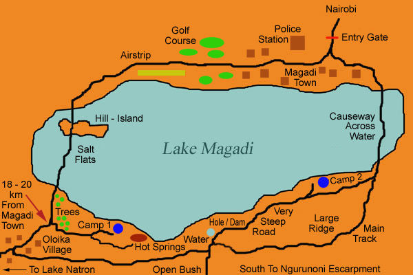
Once you are cleared to pass, you will climb up a small hill and enter the factory town of Magadi. See the map below for a reference to the specified landmarks. There are a number of shops, houses for the workers, and administrative buildings. When you reach the top of the rise, turn left. You will pass a police station on your left, then a recreation center on your right. Keep your speed down because there are many speed bumps in town. You will pass a few more houses, then the tarmac road will end. There is a golf course just beyond town, but the grass is over a meter high at times, and is not recognizable as such. Beyond the golf course is a small airstrip. Set you odometer when you leave town, you should hit the next settlement within twenty kilometers. The road will wend its way off to the right, and eventually drop you down onto the salt flats. Use extreme caution when driving on or near the salt flats. If you are not careful it is possible to become completely mired in thick mud. Check your route carefully before you cross this treacherous section. The road across the flats is not well defined, so follow the tracks of those before you. It is possible that you may see game on the flats; zebra, wildebeest, and flamingos are common. You will have to cross a small sandy hill in the middle of the flats, but the track is easy to follow. When you again reach the lakeshore, you will come across a stand of trees. When you reach the second stand of trees, there will be a track that branches off to the right. The track takes you back down to the lake. Here is where Camp 1 is located, as well as some hot springs. If you are exhausted from the day's driving sleep here. While it is only another 25-30 KM to the next camp site, expect the going to be extremely slow and allow 2-3 hours to cover the distance. You will want the time to explore.
If you continue on you will soon reach a small village. The road will enter Oloika Village. The town is tiny and the buildings are set well back from the road. About halfway through town a nearly indistinguishable path will peel off to the left between two buildings. The path is so seldom used that you will be convinced that you are headed the wrong direction. Stop and ask directions if you are unsure of the route. The people are friendly but few speak English. If you follow the main road through town it will eventually lead to another village and perhaps even to Lake Natron. When you turn left, you may find the way barred by a temporary fence of acacia brush and logs. The purpose for the roadblock is unclear, but simply drive around it. You are allowed to pass. You will drive by a schoolhouse, and then be off into the bush. This is a very pleasant part of the drive, but be cautious of you direction because the track sometimes splits and rejoins itself. Just keep heading west and you should be find. You will likely see many Maasai in this region, all of whom seem to be friendly. The road will eventually end in a T-junction. The road left leads to the remote Ngurunoni Escarpment. Turn right to head back to the lake. You will pass a small well/dam that the Maasai use to water their cattle, then the road will split. The track that splits off to the left is of better quality, but you bypass a stunning view of Lake Magadi from atop a high ridge. Camp 2 is also off of the right track. Continue right, and then the road will turn to the left just as you reach a large hill. The road plunges down a very steep grade, full of good size boulders. It is very slow going. About halfway down the road, a small trail will split off to the right. Take the turnoff and after about 200 meters the road will dead end at Camp 2. You will be greeted by a stupendous view of the lake and the campsite is wonderful. The site has a fire pit, but no other amenities.
From the campsite it is only a short drive across the lake back to the factory to complete the entire loop. It should take no more than 30 minutes. There is a small market in the town for the local Maasai. It is an excellent place stop for refreshment. Also, if you are thinking of purchasing souvenirs like Maasai blankets and the like, this is an excellent place to shop. There are many different stalls with an excellent selection. You will avoid the bustle and exorbitant prices of the bogus Maasai market in Nairobi and have the pleasure of buying the merchandise from the same place as the Maasai themselves. The local Maasai are extraordinarily friendly and you will be approached by many who wish to speak with you. Spend some time sitting in a shop speaking to the locals.
Suggested Itinerary
The Lake Magadi loop can easily be completed in two days. We suggest that you take the route as explained above to avoid climbing the boulder strewn steep road that rises from the southwestern side of the lake. In fact, the drive described above was so incredible that instead completing the loop we retraced our steps from the day before. Be aware that aside from fire pits there are no amenities at campsites. You must bring all of your food and water. There are many Maasai in the area. Expect visitors at your camp. They most likely won't hassle you, just stare and watch what you are doing. Very few Maasai speak English in this region. If you have a few extra days, consider exploring the roads to Lake Natron or the Ngurunoni Escarpment. They are extremely remote with few people traveling on them, so make sure that you are fully prepaid with sufficient food, water, petrol, and spares.